This time around, while getting ready to visit Kannavia, we decided to construct our next route in a way that would both enclose several other places and make our trip more diverse and appealing. Simultaneously, we wanted to throw out some new ideas for future journeys to you, our readers.
That said, we hadn’t envisaged that our ideas would be so impressive, nor them proving to be somewhat different from what we’d been anticipating.

The First Story or “A Dying Species”: The Villages of Pano and Kato Koutrafas
Generally speaking, Koutrafas is the common name of two neighbouring villages: upper and lower, meaning Pano and Kato Koutrafas.
Kato Koutrafas lies roughly 38 kilometres to the south-west of the capital, along the western bank of the River Elia, at an altitude of 185 metres above sea level. The south-western part of Kato Koutrafas is also connected to the smaller village of Mandres. Although both settlements are officially governed by the same authorities, today’s Mandres consists merely of several abandoned houses.
Nowadays, as in past eras, the locals grow wheat and citrus fruits on the village boundaries and outskirts.
Despite the reigning desolation and scarcity of people here, the village, nevertheless, has a long-standing history. It has existed on the island since the Frankish period when it was apparently known as Cutrafa.

As a matter of fact, the first village named Koutrafas (initially consisting only of a Greek community) was renamed Kato Koutrafas roughly in the 15th century, when the Turks founded a small settlement nearby. It was then given the name “higher” or Pano Koutrafas. Its inhabitants, however, left in 1964. As a result of the inter-communal conflicts which occurred at that time, the village has since remained wholly abandoned.
Louis de Mas Latrie, a French researcher, famous traveller and renowned connoisseur of 19th-century antiquities, who is now well-known on our site, notes that the village was once a fief belonging to the noble family De Navis, who were native to Odessa. Another scientist, Georgios Karousis, adds that in Limonidas’ manuscript, the settlement of Kato Koutrafas, amongst other things, is said to have also belonged to Count De Rousia (or De Ruscha).
There are several versions regarding the origin of the village’s name: some researchers (one of them being the already notorious Nearchos Clerides) associate the name with the first settler, who was attracted to the blooming capers in the area (Cypriots refer to its inflorescence as “koutrouvin”).
Others deem it to have originated from a family of landowners in the Frankish era, while the word “koutra” is noted to have derived from Latin.
However, supporters of yet another version insist on the settlement names being linked to the Byzantine period in the island’s history.
Whatever the case, from 1881 to 2001, the number of inhabitants in Kato Koutrafas repeatedly increased and decreased. In fact, the population in 1881 also included that of Pano Koutrafas, while in 1982, the count also included residents from neighbouring Mandres.
From 1973, the population of Kato has continued to decrease, with no more than 15 (this is a very approximate figure based on the 2001 census) people living permanently in the village today.
The main (and likely, only) community church is the Church of Panagia Chriselousa, which was built in the late 18th century. Although the church is known to house a very remarkable iconostasis, having a look around it is not so easy. Due to the contemporary “condition of things” in the given region, the church itself is almost a secret “enterprise”, and getting to it is no simple task.
Nevertheless — on the off chance you’re lucky, and the church is open — be aware that the local old iconostasis underwent considerable renovation work in 1927, with aid from the wonderful and famous master of those years, Evrychlidis.
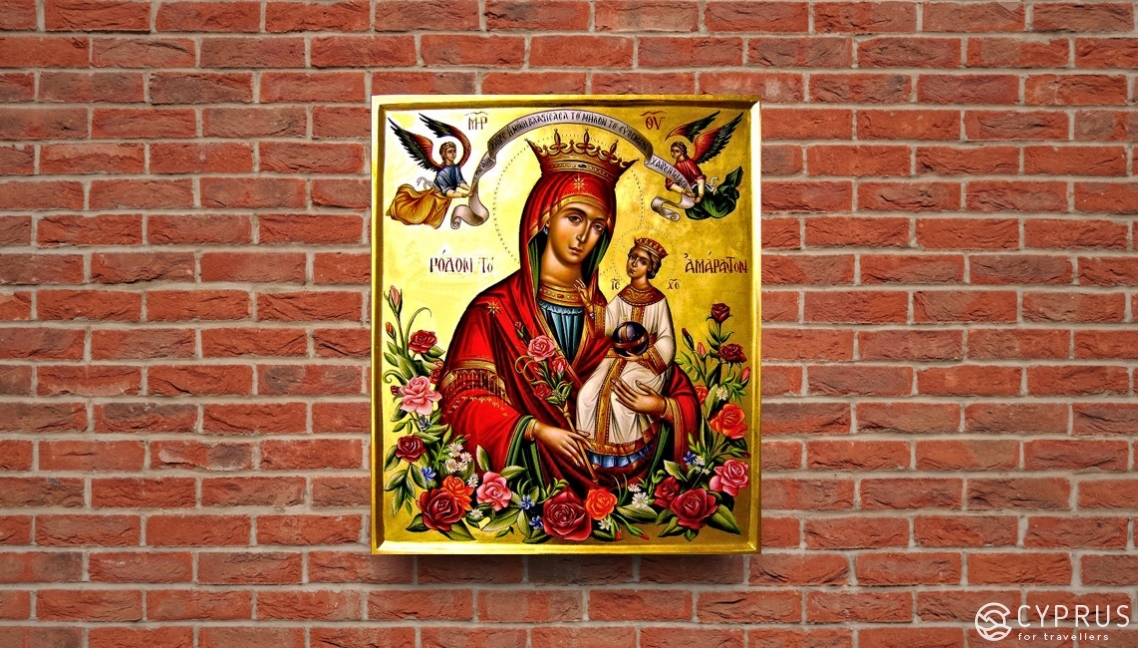
In fact, it is believed that the local church icon, the “Fragrant Flower”, or Panagia Rodon-to-Amaranto, is a miracle worker. It depicts Jesus and the Virgin Mother in wreaths; she is also holding a rose in her hands. The Virgin Mary is also known as Rosaria or The Virgin Mother of Roses, as she grew the one true Rose — her son Jesus.
Like the Apostle, Paul said: “For we are a fragrance of Christ to God among those who are being saved and among those who are perishing” (2 Corinthians 2:15).
As a matter of fact, this image (relating to the iconographic type “Hodegetria”) is one of the most famous, ancient and revered sacred objects of Orthodoxy, which those faithful come to worship in the most challenging situations.
As soon as we arrived here, we were staggered, let’s say almost immediately, by a lot of things.
Firstly, the general impression of “stagnation” and “desolation” in Koutrafas, from the more or less standard image of a Cypriot village.
At that time, it honestly seemed to us that everything was wrong here. In fact: as you enter at the signs posted, you constantly begin to feel you’re the target of cameras and warning signs displaying the message “No Videos” — due to the close proximity of some bases…. Regardless of the scenic slopes, open spaces and abundance of greenery, this sense of oppression is only amplified when you move ahead, in an attempt to taste the local spirit and tap into the atmosphere.
Here, however, there isn’t one, or it likely exists, but it’s not linked whatsoever to people.
Many who have at least once watched the famous film “Stalker” by Andrey Tarkovsky will understand what I mean: an oblivion-filled silence enveloping any strangers who venture here, with nature inexorably wiping out traces of those who have left.

Although unlike in the famous saga, people still live here, it’s as though the environment is driving them away, so it’s hardly likely that something “touristy” or at least a form of “mass-entertainment” will appear shortly.
All this, despite the picturesque remains of old buildings, stone bridges and a small dam in the vicinity (The new village website, which isn’t complete yet, will soon tell you about all the sights. We’ll give you the link to it a little later).
Moreover, no matter how proactive we were with our sat-nav, or delved intently into the scarce details marked on google maps, what turned out to be there differed radically from what had been “promised”.
One thing is for sure: today, you’re unable to discern that this was once two villages and separate societies of Turks and Greek-Cypriots.
As it had been understandably abandoned by Turkish-Cypriots in the mid-1960s, we didn’t have any particular expectations of seeing the village in a well-preserved condition.
It was interesting to delve into the past and if lucky enough, take a small glance at the village's present. According to all laws of genre, it should have been completely alive and inhabited. Nevertheless, what we saw was shocking: nowadays, you don’t often encounter such sights in Cyprus.
Your typical Cypriot village, with a designated centre and some signs of community life, were nowhere to be seen. The only exception was the church-chapel of Panagia Roda which towered in solitude at the village entrance. It was also equipped with a ubiquitous array of cameras and a pre-emptive sign unequivocally prohibiting the filming of videos nearby.
Further on, the road led between rows of friendly car garage-workshops — completely deserted and devoid of people despite it being a workday — to several houses surrounded by small plantations.
You could see two-three farms scattered across the green hillsides, and the remains of old rural constructs abandoned by their former owners so long ago that trees and bushes had already grown in their walls.
These constructs and remains don't merely appeal with their flair of the past but afford us the worthwhile opportunity to study one of the most popular types of stone construction on the island, one which existed in the Troodos foothills and the mountain region itself.
I’m speaking about the characteristic combination of stone masonry using unhewn raw stone, or large fragments of mountain rock and shingle, which were delivered by storm flows in wintertimes. This also concerns adobes, which villagers across the entire island produced themselves from clay and chopped straw.
Koutrafas houses some beautiful samples!
However, I’d just like to caution you against exploring these or any other unfortunate island ruins: and not only because the old walls are far from being as stable as they might appear.
Many of the traditional houses in the Troodos have a lower level (a cellar). Over time, if the owner abandoned their home long ago, it could have turned into a dangerous trap due to the overgrown plant branches which have covered it, as well as amassed earth and layers of green soil.
This is vital to remember if you end up in a place without any people.
Even being aware of this and just by standing in the courtyard of one of these houses to properly examine an old oven, I suddenly felt the soil underneath me become suspiciously soft. Elastic even.
Having headed away from this spot towards the highway leading to the farms, I noticed that a small hole had begun to form literally in the very place where I’d been standing.
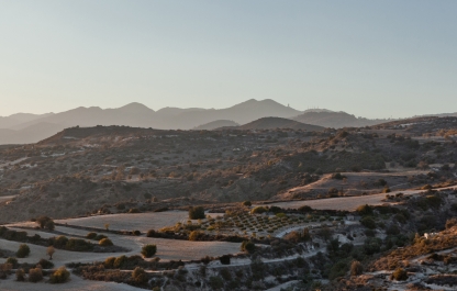
As for the ghost-village indicated on the map, we couldn’t even find traces of it. Behind today’s Koutrafas (I’ll remind you, this was, conditionally speaking, the “lower” of the two villages — Kato) you can see stunning hills and foothills spread out. Their slopes are covered with genuinely magnificent gardens and olive groves which are worth feasting your eyes on if you’ve stopped for a short while on the roadside.
We didn’t notice any remains of buildings, nor old roads or other traces of this place once having been inhabited. That being said, on the same day (to be more precise, during a magical, profound twilight on the Troodos) something else lay in store for us. We got to know the locals of another small, historical and fascinating village, who stated it was in the “gardens of Koutrafas” where the previously abandoned village of Pano Koutrafas was once situated.
So, we’ll say from the off: it’s not worth coming here especially. Aside from the strange experience, you won’t benefit considerably from visiting Koutrafas: if you’re not purposefully going to see the icon of Panagia, of course.
It’s unlikely you’ll be welcome here... especially if you only come across soldiers and aren’t lucky enough to meet any of the peaceful inhabitants. I, for instance, wasn’t — in the short time I was there, I tried to at least have a look around and soak up my surroundings, as they say, but without any information or cause whatsoever, I unexpectedly “had a course set on me”.
It was an old, long-haired woman who seemed to have come from nowhere. Immediately, without any ado, she began her persistent pursuing me with accompanying loud shrieks. She had definitely made her way into the local pastoral setting from the pages of the somewhat gloomy Tales of Brothers Grimm.
Thus, I was in rather tricky field conditions and trying to imperceptibly maintain a safe distance from my tireless pursuant waving her arms around, eager to close in on me. In the midst of this, while trying to film at least something unprohibited, I completed a lap of honour around the vicinity.
We then cunningly manoeuvred ourselves between the old ruins, thanks to which we were able to get rid of our “tail”, and then set a course for Kannavia.
As you’ve probably realised, we wouldn’t go to great lengths to recommend Koutrafas as a separate visit. However, if you’ve got a great wish to do so and time to play with, you can easily make a detour to the close-lying and comparatively dynamic, developing villages, where there’s something to see, someone to converse with and somewhere to wander around (Vizakia, Nikitari, Potami, Kannavia, Agios Georgios etc.).

For more information, please see here and here.
To establish friendly contacts with the local community, this information may be useful to you:
Telephone: (+357) 22852067, Email: k.s.koutrafas@gmail.com.
So, after enjoying the view of the local hills and Troodos foothills while on your way to Kannavia, you can make (“latch” onto your trip, so to speak) a visit to Vizaki and stop there for a short rest, as we did.
This time, we had the opportunity to better inspect this very familiar, welcoming village, as we got there before nightfall and had our bearings a little thanks to our last trip here. Thus, we were able to relax in a small square with a playground near the church of Ayia Ekaterina (dated 1925). There is also a good parking spot surrounded by ancient olives trees.
We then continued our journey, and having steered onto the road leading around the hill, began to climb higher into the mountains. Landscapes became all the more fascinating and picturesque.
And so we arrived at the village.
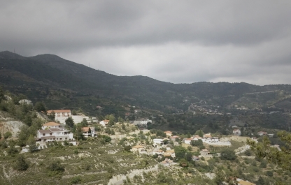
The Second Story: The Amazing and Unexpected Kannavia
As you can read in various guides and blogs, this is one of the most beautiful villages in the Nicosia region. Unsurprisingly, Kannavia (in Greek: Καννάβια) is located on the northern slopes of the Troodos mountain range in the valley of the River Elia, at a distance of 52 km south-west of the capital.
Aside from the immediate vicinity of Kannavia, the small settlement of Kapura is also part of the local municipality. The village itself is located on the northern slope of Mount Madari, at an altitude of 800m above sea level.
The village is, by and large, located in a wooded area (part of the so-called Adelphi forest). To the north-west of the village, roughly 4 km away, lies the Kapoor picnic area, which is close to a fire station of the same name, at an altitude of 200 m above sea level and with a capacity of up to 200 people.
Needless to say, nature has generously endowed the village and its surrounding lands with stunning mountain vistas and magnificent green forests, with an area totalling 1380 hectares.
The remaining territory is used for cultivating various crops. You used to find numerous vineyards here (due to periodically occurring droughts, residents began to devote less effort and attention to viticulture in Kannavia, although some still do so). Today, olive and almond groves predominate. There are also fruit orchards growing a lot of apple and persimmon trees.
According to Mas Latrie, the village has existed since the reign of the Franks, as a royal fief. On ancient maps, you can find the local village designated as Cannania.
Although the origin of the village’s name is not known for sure, it is believed to most likely be associated with the cannabis plant (in Greek — κάνναβη), which, according to the Great Cyprus Encyclopedia, was rather widely cultivated in the village in the past.
In fact, in the Greek-Cypriot dialect, the name of the village sounds like “Kannavkia”.
Nowadays, while strolling through the village, you can see houses of modern and traditional rural architecture and even some suburban residences.
The views of the steep slopes, as well as the village itself, which stretches along the F929 mountain road, will surely make you stay here for a while to have a walk and explore the surroundings. Believe me, it's definitely worth it!
Our first time here probably captured one of the most fruitful times of the yea. The late autumn still gifts you with the heat accumulated over the summer and the foliage strikes you with its sheer density; that being said, the colours of nature are already enriched with golden, orange and purple hues.
We left the car by the main road and headed upwards along Agias street (even judging by the name, you can guess that this path will lead us to a church). A mighty, old and massive oak tree towers higher up along the slope, surrounded by rather small rural and suburban houses with dense grape vines running over their verandas and balconies. Several roads scatter in different directions from where the tree stands.
Everything is generally like in the Russian epic-folk tales about the Goryuch-Kamen: to the right or ahead — wherever you go, you will find something ...
Here you can find the village centre, with a cosy square and a public relaxation area. It lies under a remarkable trio of trees, composed of an old, spreading oak, a plane and an olive tree. You also have historical sites with several attractions all at once ...

It’s worth seeing, for instance, one of the largest [1] village fountains (1951) on the island: nowadays, it is both a stone-slabbed spring (there are even three) with a pool located next to it.
Here we can see terraced irrigation canals, both a part of the village’s water system and a memorable ensemble.

Besides, this is an exciting local attraction: a modern square has been crafted around the fountain, with evening lighting and paved paths.
But we continue to ascend ...
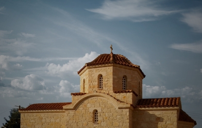
Yes, it turned out like this: the main road led us not only to one church — the ancient church of Panagia Kazaviotissa — the main church of Kannavia, but a second one — also dedicated to the Virgin Mother.
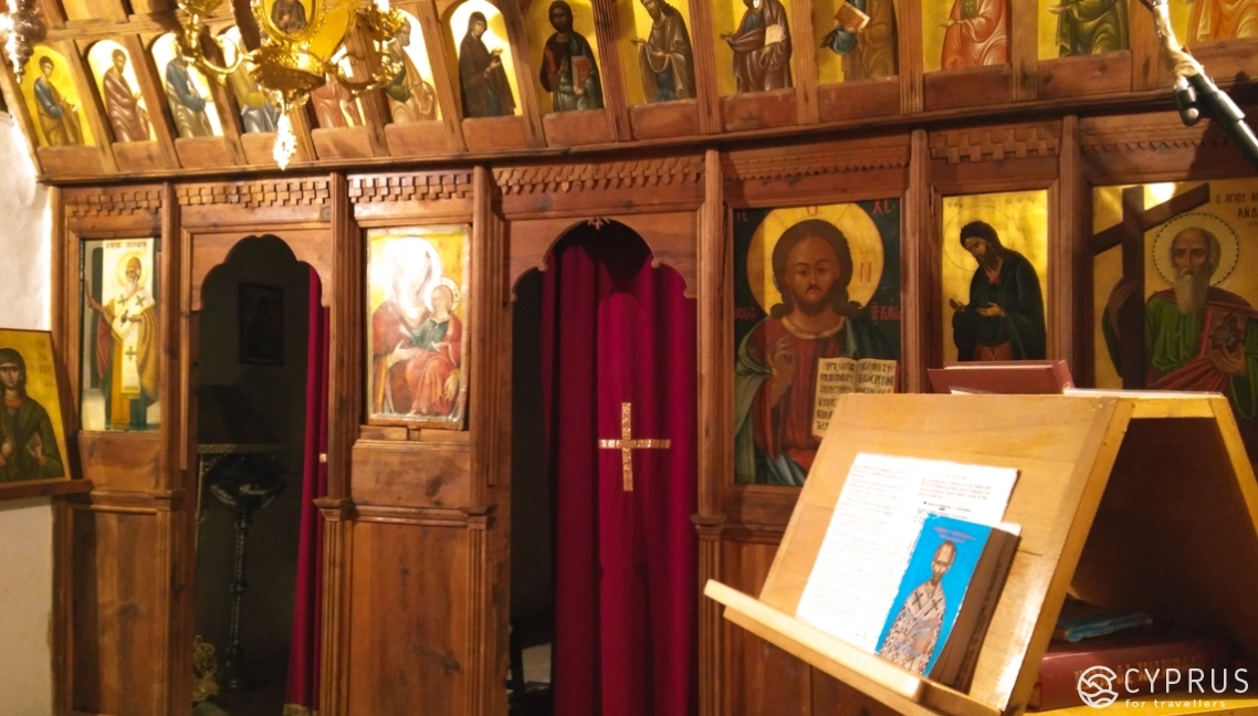
This is the main village church. A stone, single-nave structure with wooden roofing (the so-called "tis-stegis", typical for church architecture in the Troodos mountain region) and an iconostasis under the protection of the island’s Department of Antiquities.
Though the church was built in 1800, it is not known precisely when it was opened to parishioners, since the old altar stone on which this date is etched was later replaced. At the same time, it is documented that the second, relatively new church of Kannavia was erected on the foundation of an old church. All that remains of it is the icon of the Mother of God.

The ruined church was part of a monastery which ceased to exist in the XVIII century.
In the same spot, you can go up to the new church just above it, and also to Panagia (opened on the 26th September 2015 with the blessing and in the presence of the Bishop of Morphou, Neophytos) It has a beautifully crafted low, two-tier modern iconostasis. Works on the interior are still underway.
Тhe icon of the Blessed Virgin Mother, “The Inexhaustible Chalice” [2] (“Παναγίας της Απολυτρώσεως των εξηρτημένων” and “αοανεξάντλητοΠοτήριο”), provides effective aid in ridding people of addictions to alcohol, tobacco and drugs. According to tradition, it is a copy of a 14th-century Russian miracle icon, once located in the Vvedensky Vladychny Monastery [3] (founded in 1360 by the prelate of Moscow, Alexey, at the behest of the Blessed Virgin Mother, whose voice once called out to him from the icon).
The icon depicts the Infant Christ standing in a Chalice — a symbol of communion. The Mother of God is also depicted standing behind her Son, with raised hands. The Blessed Virgin Mary prays for suffering sinners while calling all believers to commune with the source of Goodness, spiritual comfort and pure joy.
The current location of the venerated image remains unknown (the icon was lost in 1929 [4] when the monastery was subjected to destruction and ruin).
On the other hand, a relatively new icon was crafted in 1992 by the famous Russian icon painter, Alexander Sokolov (1960-2014), using preserved photographs. You can see the icon today and worship it in the Serpukhov Vysotsky Monastery, founded by St. Athanasius Vysotsky (1340 – after 1410), a student of the venerable St. Sergius of Radonezh and the first abbot of the monastery.
In our time, the manuscript of the “Inexhaustible Chalice” is well known for attracting many pilgrims to the walls of the monastery and, being in the Pokrovsky church, it is always decorated with fresh flowers. The rite of blessing water is performed before this image daily.
Back to Kannavia.
Both churches of Panagia have the contact number of the local priest, Father Georgios Alexandrou (tel: (+357) 99 18 88 35), with whom you can arrange visits to these churches, find out when services are held and, perhaps, obtain interesting information about the village and its inhabitants.
Incidentally, during our visit to the village, although the square was already laid out and trees and saplings had been planted, construction continued, and some unfinished buildings towered around the new church.
From above, a beautiful view of the mountains, the village and the area surrounding the old church was revealed.
In the hour when we found ourselves at the hill summit, the smell of dried grass and damp foliage, mixed with smoke from kindled fireplaces, cascaded into the suddenly chilly evening air. Fires began to burn in many houses, and for some time, the mountain road at the entrance to the village suddenly became more lively.
After looking around and enjoying this spectacle, we descended to the village entrance and then began to climb up the hill again, a little further along one of the small streets [5].
We soon discovered another one of the old churches, Agios Georgios: a medieval (approximately late 13th-century), single-nave build with an apse and small iconostasis.
This was, evidently, the highest point in the village. From a small and cosy square around the church, a breathtaking view of the surroundings was revealed.
We were lucky: at that rather late evening hour, the church proved to be open due to restoration work, under the vigilant control of the Department of Antiquities.
We met and chatted there with local residents Mr Critonas, a former firefighter who now works simultaneously as a farmer and builder, and his wife, Ms Paraskevi.
Soon after, we were sitting in the cosy kitchen of their old house, whose terrace was hanging over the mountain road. It now revealed an almost night view of the mountains and a small wooded gorge, both wrapped in a rich twilight.
We slowly talked with our hospitable hosts about this and that, drinking Cypriot coffee and treating ourselves to the freshest palouze, which literally melted in your mouth ...
Here is what we learned about Kannavia from that evening conversation.
During restoration work on the walls of this ancient, albeit reconstructed church (roughly 19th-century masonry, but possibly from older eras), rare frescoes were discovered.
The roofing, as you can see from the condition and exterior surface of the wooden boards, is authentic. As we were told, it was re-covered in past eras, on several occasions. Traces of previously applied floral patterns were found on 300-year-old pine boards, which you can examine today in full.
The Department of Antiquities no longer permits any renewals (after the main restoration in 1993). Even the reconstruction of lost fragments is prohibited.
The stone floor slabs have survived to this day: from the church of the first construction.
Strange as it may seem, the former rural master builders who rebuilt this church in the 19th century didn’t revere the worn-out antique. Thus, for some reason, the apse on the central stone is indicated as having a construction date of 1893 — the time of the later, single-nave construction (Editor’s note E. KT: this is the date marked on the village website as the time of the church’s creation. Evidently, other accurate, confirmed historical information regarding the earlier construction was either not preserved, or serious research has not yet been carried out, and all of this lies ahead).
Nevertheless, even without being a great connoisseur of historical architecture, any visitor will, no doubt, be able to feel the real antiquity within these walls.
Despite the ongoing restoration works, the church is still functioning, and services are held there on Wednesdays.
According to our new acquaintances, 150 people currently reside here permanently, although official figures indicate a slightly larger number.
As we learnt, particular attention has been devoted to the activities of the local youth, consisting of a joint Kannavia — Ayia Irini Youth Centre, founded in 2009 as a local youth volunteer organisation under the auspices of the Cyprus Youth Council.
The centre provides young people with the opportunity to participate in events held in both communities. They can share their thoughts and discuss various topics with peers, collaborate with other organisations, youth centres and councils, as well as provide any possible assistance to their fellow villagers if necessary.

There are several UNESCO World Heritage Sites nearby Kannavia, consisting namely of three painted Troodos churches located not too far from you, which are worth visiting if possible:
- Panagia Asinou (initially erected in 1099-1105 and then completed at the turn of the XIII-XIV centuries, located 26 km away and close to Nikitari);
- The only three-nave church in the district — Panagia Chrysokurdaliotissa, built in the 16th century (in Spilia – Kurdali, 17 km away);
- And, of course, although situated a little more distant from the village, there is Ayia-tu-Ayiasmati (1494) — a unique, former monastery located in the vicinity of Platanistasa, roughly 30 km to the southeast.
In general, this welcoming village is conveniently accessible from practically all of the island’s cities: Limassol, Nicosia, Paphos, Larnaca and Kyrenia.
Besides, there is a country road which also acts as the Selladi-tou-Karamanli nature trail, going from Saranti village and ending in Spilia. The track is part paved and part consisting of a dirt road. Kannavia stands as the endpoint for this fascinating and popular tourist route, which is most often covered on bicycles.
Duration: 3.8 km (about 1 hour by bike).
Throughout the trail, you will encounter forest plots, as well as views of Kannavia and Agia Irini Valley. This path is connected to several hiking trails in Pitsilia, for example, Mardari – Selladi-tou- Karamanli and Moutti-tou-Stavrou – Selladi-tou-Karamanli.
It’s worth bearing in mind that the second part of the path is entirely dirt road, with paving only near Kannavia. A campsite has also been set up nearby.
Please make note: there is an old reservoir near the village. Ask the locals, and they will definitely tell you how best to reach it.
If, one day, you decide to escape here into the mountains, away from civilisation, then please do not forget to follow the basic rules: do not litter, do not break branches and do not collect plants for flower bouquets (many endemic plants grow on Troodos), do not ruin any nests and try not to create excessive noise (for the same reason: some species of birds and animals are also local endemics). Igniting fires outdoors is also prohibited everywhere in Cyprus.
And leave your vehicles, please, only on equipped sites.
If necessary and should an emergency arise, please call 1407 (the number is free and in-service 24/7).
Autumn visitors to the village — namely those who come in December — will be curious to see how the villagers distil zivania. We’ve already written both about the drink and the spellbinding process here. The cult month for making zivania traditionally falls in November.
If you’ve taken a liking to the village and want to stay here for a while, simply make yourself known to the locals.
A little higher, towering on the hill above the site where the new church of Panagia lies, you can see Lioness Fountain (since 2014) — a modern two-level villa with a swimming pool intended for rent.
Village website: www.kannavia.com.
Useful contacts in Kannavia:
Telephone: (+357) 22922377, Email: kskannavia@hotmail.com.

Getting There and Where to Eat:
So, we first went to Koutrafas-1 and Koutrafas-2 ... whatever they are called in our time, regardless of maps and navigators.
From Nicosia: drive along the Nicosia-Troodos Highway (A9) to the end, from the roundabout, come off to the right and head further along Nicosias Street (the B9 highway) until the Troodos intersection.
Turn left and follow the F932 until the signpost for Koutrafas (s).
Distance: about 54 km. Travel time: approximately 1 hour.
From Limassol — if you take the Kannavia route right away: from Pano Polemidia along the B8, through the villages of Alassa and Monagri, move to Trimiklini, then you’ll come to a fork.
Choose the direction along the E 801 — to the Karvounas intersection and from there, crossing the border with the Nicosia region, follow the signs for E 909 and then the F 944 and F 929 via Ayia Irini to Kannavia.
After enjoying a walk and exploring this village, and if you still have time to kill, you can pop into the “Frankish” Koutrafas. Roughly another 15-20 minutes further along the road.
Distance: 53 km, travel time: roughly 1 hour 10 minutes.
Does the bus go to Kannavia: it wasn’t possible to find out the Nicosia bus routes (OSEL transport company) as the website was being updated at the time.
However, for more accurate information, please contact the transport controller via the details below:
Telephone: (+357) 77 77 77 55 and Email: contactusform@osel.com.cy.
Or you can immediately go to the island’s main "bus" website and make inquiries there: www.cyprusbybus.com.
As for lunch, you’ll have to go to one of the nearby villages, as there are no such places in Kannavia.
So, you have a choice of:
Spilia (6km) and its “The Sama Tavern” (tel: (+357) 22 519559, website).
Kakopetria (15 km) — you can always choose a cafe, tavern or restaurant to your taste here and moreover all year round; this includes “The Mill” hotel (Milos St., 8): tel .: (+357) 22 922536, where you will find a bar and restaurant at your service.
Pelendri (20 km from Kannavia) — travellers here recommend visiting the “Symposio Tavern” (a vegetarian menu is available) — tel .: (+357) 99 404348.
Platanistasa (22 km away) and her wonderful cafe-tavern Achilleas, which has a dining room, billiard room and a magnificent open area under vines with panoramic vistas of the surrounding countryside.
Until Next Time for More Discoveries!
[1] Based on our own observations.
[2] You can find the following on the monastery’s website regarding the icon: “The icons of the Blessed Virgin Mary“ The Inexhaustible Chalice” of the Serpukhov Vysotsky Monastery can often be found in icon shops in the Holy Land, Cyprus, Greece, Serbia, Romania and in several other countries of the Orthodox world. On the 30th May 1997, with the blessing of His Most Holiness the Patriarch, the icon “The Inexhaustible Chalice” was first introduced into the Orthodox Church Calendar, and this “was an official act of acknowledging the nation-wide reverence towards this sacred object...”, please read here for more details: www.visotskymonastir.ru.
[3] Founded as a man’s monastery, it is now a diocesan convent.
[4] According to other sources, this happened even earlier, in 1919.
[5] As we visit different villages, we don’t always have the opportunity to tell you the exact names of certain streets: they are not always visible, and current navigators are yet to have accurate information in this regard. Because of this, you sometimes have to explain “on your fingers” — where to go, where to turn, whether to go up or down.